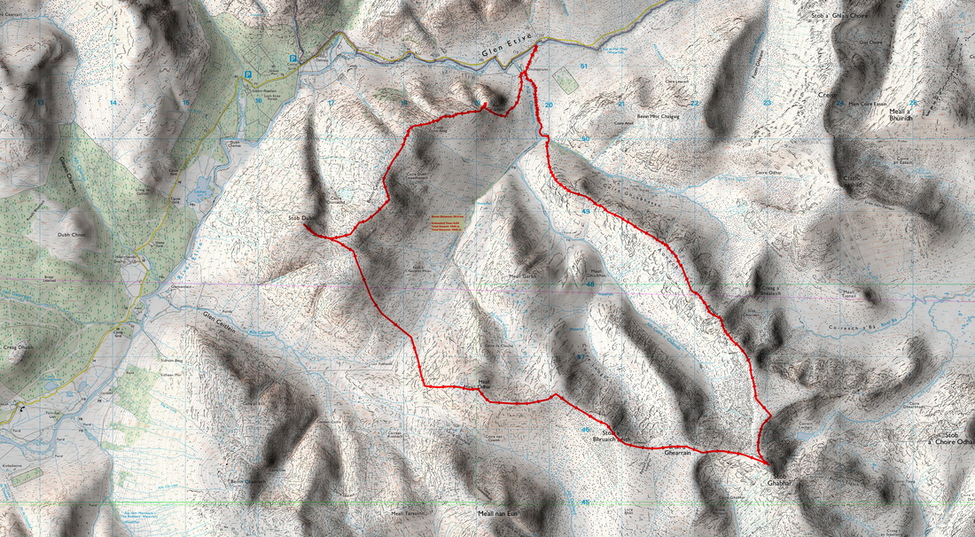
Stob Dubh and Stob Ghabhar
MunrosStob Ghabhar
|
CorbettsStob Dubh
|
GrahamsNone
|
BothiesNone
|
Distance/Ascent21km 1845m
|
Estimated Time10h 15min
|
NotesI have long fancied the long walk north along Aonach Mor. Given favourable weather, I may bivuoac on Stob Ghabhar and have a pleasant walk back to Glen Etive the next morning. I am doing the Corbetts at a rather leisurely pace.
|
31 July - 1 August 2024
The summer has seen a lot of unsettled weather and with a planned bivouac, I wanted good weather for this one. I had to drop my wife and youngest son off at the airport and the weather forecast was reasonably good, so after getting up at 03:10, I headed down the Great Glen through Fort Bill, onwards through Glencoe and eventually turned right into Glen Etive. I had taken my time driving to Glen Etive, thinking that I had plenty of time. Glen Etive already seemed to be heaving with people. Some were battling with the midges while breaking camp. Most did not seem to be used to mountain roads and did not look ahead so they could pull up in a passing place. Perhaps their attention was more on the stunning scenery in what was developing into a stunning morning. Some just stopped and seemed to expect me to go off-road to pass them. A Vauxhall Corsa is not made for such off-road motoring.
I found suitable parking without occupying a passing place. I seem to remember the bridge at Alltchaorunn to one have been solid metal gates with barbed wire but that disappeared many years ago. It is now relatively welcoming for walkers.
I knew about the path that diverts visitors away from the house, but I instead picked up a temporary track that was constructed for the development of a small hydro-electric scheme. Reading about this online, there were reassurances to cause minimum environmental impact but this seems to amount to the erecting of a deer fence and allowing nature to slowly heal the scarred hillside.
After dropping down towards the house in order to access the bridge to the West Bank of burn, I walked up a faint track rising below An Grianan. I was a bit concerned about the numerous insects, as I tried to distinguish between friend and foe.
It was a hard pull up to the east ridge above An Grianan; a combination of not exercising enough, age and carrying the extra overnight gear. Once reaching the ridge, the gradient eased and there was the psychological gain of being able to see the magnificent peaks to the north. Also, taking photographs acts as a small rest.
I saw a dragon fly but did not want to peruse it all over the mountain as I knew it could move a lot faster than I but I later came across this female common hawker, which did not seem to want to fly away. maybe it was looking to lay its eggs or something. I probably spent the best part of 20 minutes trying to photograph it from the best angles as well as repositioning it on some bog asphodel flowers.
Then it was onwards and upwards, eventually ditching my backpack at the saddle before the final rise to the summit of Stob Dubh. It was nice to do the last bit with just a camera, small tripod and a drinks bottle.
On the summit of Stob Dubh with Buachaille Etive Beag and Buachaille Etive Mòr as a back-drop.
Over the preceding weeks, I had been suffering from a "dodgy" knee. It had started while descending Càrn na Coinnich a month earlier. I had been going down steep hillside and my right leg landed with a straight knee. It was nothing excruciating but I felt the strain on the ligaments, especially on the outside of the knee and the top of the calf. In the mean time, the discomfort has not been continuous and has been most evident when getting up after sitting of a period of time. My lack of fitness meant that I am slow going uphill and my dodgy knee meant that I was not much quicker going downhill. Once across the beach it is a steep uphill. I would have stopped for longer rests had it not been for the midges. Applying Smidge did help a bit, but my bare arms were spotted with the corpses of dead midges.
The sun is setting behind Sgòr na h-Ulaidh with Stob Dubh nearer and to the right.
I had been hoping for a fine night like my summit/high level camps on Ben Chonzie and Ben Vorlich but as I approached the summit of Stob Gabhar in fading light, it was clouding over and then began the spots of rain. On reaching the summit, I should have cooked a meal but I was very tired and just made do with a snack and a drink of water. An evening meal is important part of the recovery ahead of the next day's hike. I had done most of the ascent but I was at the most distant point of the route.
I was trying out a new bivvy bag which I had bought a year previously but not used. For many years, I used a double hooped bivvy tent. I tried to insert a thin foam mat into the bag but this proved difficult as it just folded up. My concern was that if I left it on the outside, I could roll off and it would blow away. I was shivering a bit, another consequence of a lack of food, but I did warm up after a while. I did find it very claustrophobic and I had a sense of not being able to breath. I tried to open the zip a bit but struggled to find the end of the zip, initially sliding the one for the midge netting. I did eventually create an opening which I faced down towards the ground so that any rain did not enter. I woke up a couple of times but slept reasonably well.
I woke up to a wet mist and a fair breeze. I packed up my kit, ate a cereal bar and set off back to the car. With the steep carries, navigation was straightforward but It was nice to have glimpses of the surrounding terrain to confirm that I was on course.
It is a fine long ridge and but if finally came to an end and I descended to the hydroelectric installations above Alltchaorunn passing dancing Scotch Argus butterflies. I wanted to obtain a better photograph, but they were fairly skittish and '" could not get very "close" to them with with a maximum focal length of 40mm. Lower down, there are waterfalls and water slides with beautiful pools of clear water. For whatever reason, the water is totally clear here and not coloured by peat.
This route was planned over 10 years earlier so it is very satisfying to finally complete it. Four more Corbetts to go!